South Central
Main article: South Central Alaska
The most populous region of Alaska, containing Anchorage, the Matanuska-Susitna Valley and the Kenai Peninsula. Rural, mostly unpopulated areas south of the Alaska Range and west of the Wrangell Mountains also fall within the definition of South Central, as do the Prince William Sound area and the communities of Cordova and Valdez.[10]Southeast
Main article: Southeast Alaska
Also referred to as the Panhandle or Inside Passage, this is the
region of Alaska closest to the rest of the United States. As such, this
was where most of the initial non-indigenous settlement occurred in the
years following the Alaska Purchase. The region is dominated by the Alexander Archipelago as well as the Tongass National Forest, the largest national forest in the United States. It contains the state capital Juneau, the former capital Sitka, and Ketchikan, at one time Alaska's largest city.[11] The Alaska Marine Highway provides a vital surface transportation link throughout the area, as only three communities (Haines, Hyder and Skagway) enjoy direct connections to the contiguous North American road system.[12] Officially designated in 1963.[13]Interior
Main article: Alaska Interior
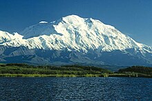
Denali is the highest peak in North America.
Southwest
Main article: Southwest Alaska
North Slope
Main article: Alaska North Slope
The North Slope is mostly tundra peppered with small villages. The area is known for its massive reserves of crude oil, and contains both the National Petroleum Reserve–Alaska and the Prudhoe Bay Oil Field.[14] Barrow, the northernmost city in the United States, is located here. The Northwest Arctic area, anchored by Kotzebue and also containing the Kobuk River valley, is often regarded as being part of this region. However, the respective Inupiat of the North Slope and of the Northwest Arctic seldom consider themselves to be one people[citation needed].Aleutian Islands
Main article: Aleutian Islands
More than 300 small volcanic islands make up this chain, which
stretches over 1,200 miles (1,900 km) into the Pacific Ocean. Some of
these islands fall in the Eastern Hemisphere, but the International Date Line was drawn west of 180° to keep the whole state, and thus the entire North American continent, within the same legal day. Two of the islands, Attu and Kiska, were occupied by Japanese forces during World War II.


No comments:
Post a Comment